
Utility survey teams across Norway work in hard seasonal windows. When the snow melts, hundreds of field workers need to geo-mark infrastructure — gas lines, water mains, electrical conduits — across hundreds of square miles. A single mis-marked utility line means excavation damage, safety incidents, or regulatory penalties.
For years, the answer was paper forms and manual data re-entry. When mobile apps arrived, most companies made the same mistake: backend developers, cross-platform framework, shipped fast — and it crashed in the field, lost data, and didn't work offline. A screen was added to a broken process.
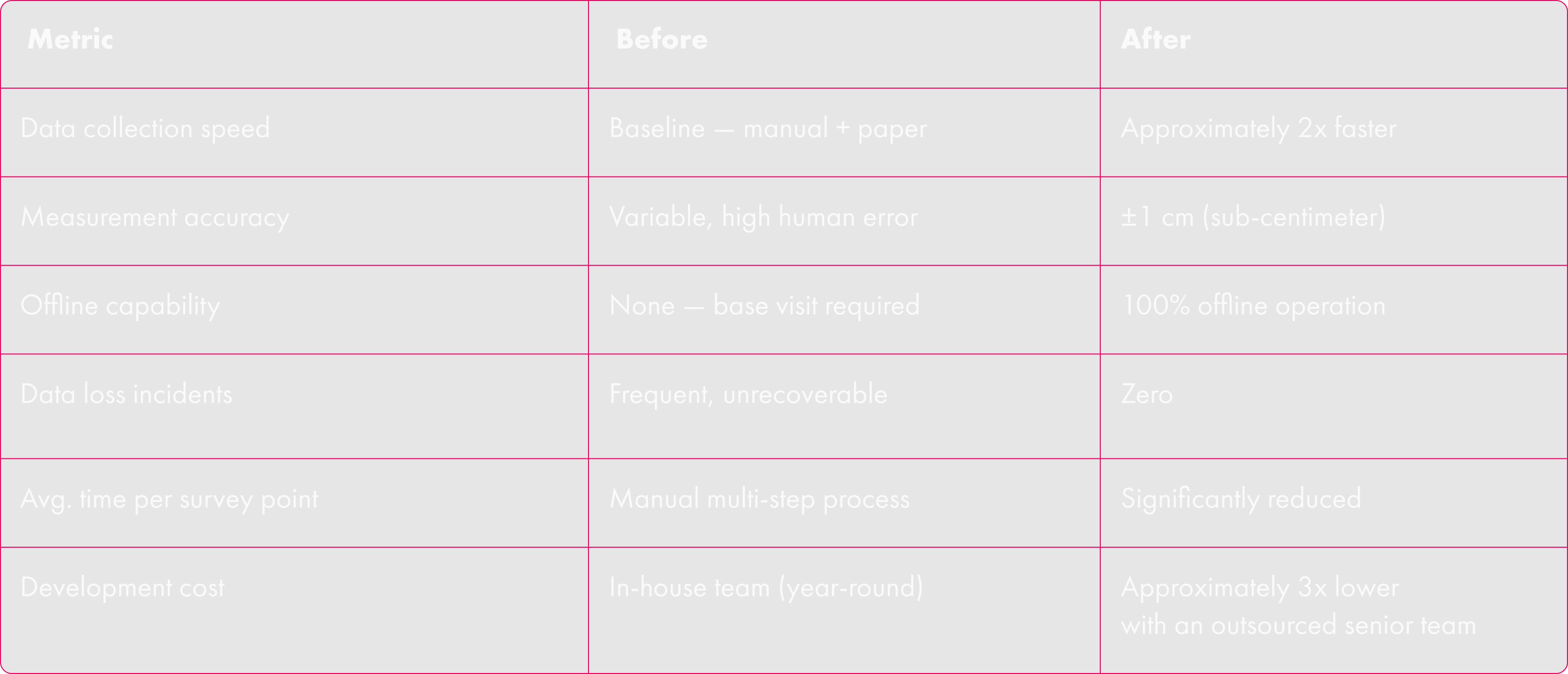
This is how a dual-app platform — native Android, ARCore, and GNSS+RTK hardware integration — replaced five years of that for a utility company with 50 field workers. Sub-centimeter precision, 100% offline, 2x faster data collection, 3x cheaper than in-house.
TL;DR: 50 field workers, chronic data loss, no way to catch worker fraud. A dual-app AR + GNSS solution approximately doubled field team throughput, eliminated data loss, and cost a fraction of what an in-house team would require.
Quality Wolves is a senior-only engineering agency specializing in native mobile, AR, IoT, and GIS systems. This is how we approached the problem.
The Problem: What Five Years of Workarounds Actually Cost
The manual process — and its real price tag
The original workflow was entirely manual. Field workers drove to a survey zone, walked the area with GNSS receivers and RTK antennas, and hand-recorded coordinates for each asset — valves, pipe junctions, entry points. At the end of the day, they returned to base and transcribed everything into QGIS. A team of 50 workers running this process in remote locations — where LTE disappears entirely — carried significant labor costs. Three additional senior engineers maintained the technical infrastructure year-round.
Every manual step was a data integrity risk: transcription errors, misread coordinates, lost field notes. And because the process depended entirely on workers' self-reporting progress, there was no objective way to verify that work had actually been done.
The failed in-house app
The company's internal team — primarily backend engineers — built a cross-platform app to digitize the process. The intent was right. The tools and the team were not. The result was predictably unstable:
- App crashed regularly in field conditions, blocking entire work sessions
- Data was silently discarded — sync appeared successful, but records never reached the server
- No offline mode meant driving to connectivity just to submit a day's work
- UI was unusable in sub-zero temperatures while wearing field gloves
- Cross-platform overhead for a 100% Android team added cost with zero benefit
The deepest cost was operational. Workers learned that app instability gave them cover. Some falsified entries or claimed crashes to avoid completing tasks — then billed for the time. The system had no way to distinguish a real technical failure from deliberate sabotage. Managers couldn't tell which was which. And during the working season — when fixing the app mattered most — the internal dev team was buried in bug fixes and couldn't ship anything new. Features only happened in the off-season. It was a permanent catch-up cycle.
The company eventually decided to find an outside team with genuine native mobile expertise. They ran a competitive selection: gave multiple vendors a one-week test assignment to build one of the core features — AR point capture with JSON export. Quality Wolves delivered a clean, working demo in a week, with the output formatted exactly as requested. The competing vendor spent over a month discussing UI redesigns without producing a working demo. The choice was straightforward.
The Solution: Two Apps, Each Built for One Job
The Quality Wolves team's core architectural insight was that utility geo-marking involves two fundamentally different tasks that require different tools, hardware, and skill levels. Rather than forcing a compromise, we proposed splitting the solution into two purpose-built apps — an approach the client had not considered before.
Task one is scouting: walking a corridor, tracing infrastructure paths, and marking anchor points. Spatial awareness work that needs speed and mobility, not centimeter precision. Task two is surveying: capturing precise geo-coordinates of those anchor points with specialist hardware—precision work, not speed work. Separating them into two apps lets both happen simultaneously, by different team members, at different speeds.
Locator — AR scouting with just a smartphone
Locator gives any field worker the ability to virtually trace utility infrastructure using augmented reality on a standard Android phone — no external hardware, no specialist training. Using ARCore, the worker walks the corridor and marks utility line paths and anchor points directly in AR, overlaid on their physical view of the environment.
Everything is stored locally. The entire scouting pass works with zero connectivity. Data syncs automatically when the device returns to coverage. Workers never need to visit a base to complete a session.
Separating scouting from surveying enables parallel workflows: while scouts trace new corridors, surveyors are already capturing precise coordinates for yesterday's anchor points. Team throughput stops being sequential and becomes multiplicative.
The technical foundation for this is ARCore's spatial anchoring system, which maps anchor points to physical locations in the real world and persists them across sessions. A scout can mark an anchor, close the app, hand the phone to a colleague, and that anchor will be exactly where it was left — correctly positioned relative to the physical environment. This persistence is what makes AR a practical field tool rather than a demonstration technology.
Surveyor — sub-centimeter precision via GNSS+RTK
Surveyor is built for specialist technicians with external Bluetooth GNSS receivers. It integrates directly with the hardware, applies real-time RTK correction, and delivers positioning accuracy under 1 centimeter — the standard required for utility asset mapping.
When a surveyor opens the app, they see a map of nearby anchor points identified by Locator, with indicators showing which still need precise measurement. Navigate, capture, continue — entirely offline. Data queues locally and syncs when connectivity returns.
Backend rubbersheeting — how relative paths become precise maps
Locator captures relative paths — the shape and direction of utility lines relative to anchor points. Surveyor captures absolute coordinates for those anchor points with sub-centimeter precision. The backend combines both datasets using a rubbersheeting algorithm to calculate the final, precise geo-positions of entire utility line networks. Neither app needs to solve the full positioning problem independently, and this approach sidesteps existing patent constraints on combining AR and live GNSS positioning simultaneously in a single field device.
Three Technical Decisions That Determined the Outcome
Native Android only
Field teams in utilities use rugged Android hardware. Building a cross-platform for iOS, nobody would use added complexity and creating a performance ceiling that killed the the previous app. ARCore performance, real-time Bluetooth GNSS communication, all-day battery optimization, and outdoor UI visibility all require platform-level access that cross-platform frameworks constrain. This isn't theoretical — it's exactly what caused the previous app to fail.
This was one of the first recommendations Quality Wolves made — and one of the most important. Senior mobile engineers recognize platform traps immediately; generalist teams often don't, until it's too late.
Offline-first as architecture, not a feature
Offline capability treated as a feature gets bolted on late and breaks in the field. Offline-first means every write happens locally first, sync is asynchronous and resumable, and connectivity is assumed unreliable from the start.
Every write operation happens locally first. Server synchronization is asynchronous, triggered opportunistically when connectivity appears, and resumable without data loss if interrupted. For utility field teams working in remote locations, this isn't a nice-to-have — it's the difference between an app that works and one that doesn't.
The original app sent entire work sessions as single data packets, which timed out over weak connections and lost data. The replacement uses chunked resumable uploads that work reliably even on 2G.
Fraud prevention through workflow design
The fraud problem wasn't solved by surveillance — it was solved by making it structurally impossible to skip work. Sequential step enforcement means a later step can't be completed without all prior steps being recorded. GPS timestamping logs every discrete action. Geotagged photos are locked with metadata at capture time. Statistical anomaly detection flags completion patterns inconsistent with the task type.
These mechanisms protect honest workers as much as they catch dishonest ones. When a genuine technical failure occurs, the audit trail proves it. Disputes that previously had no resolution now have clear evidence.
Results
The economic case
The in-house team maintaining the previous system represented a significant ongoing cost — engineers, maintenance overhead, and the indirect costs of data loss incidents and disputed work records. The outsourced senior-only team delivered the replacement at approximately 3x lower annual cost, with a system that performs significantly better, requires less maintenance, and supports faster feature development.
The operational upside is larger. A team that processes approximately twice the work orders per season can either reduce headcount or take on twice the contracted volume. For a company that also sells geo-marking services to third-party clients, doubling throughput directly doubles potential revenue from the same labor base.
Delivered on a hard deadline
Utility field work in northern climates has a hard seasonal window. Missing the spring deployment deadline meant a lost season — not delayed features, but an entire operating year of reduced capacity. This made timeline a first-class requirement from day one, not an afterthought.
The first working demo was delivered within one week of engagement. A production-ready build with full hardware integration, offline sync, and backend connectivity was deployed to the 50-person field team within the agreed timeline — on deadline and on budget. A competing vendor running in parallel on a similar brief spent over a month in UI design discussions without delivering a working demo at all.
At Quality Wolves, hitting the first seasonal deadline wasn't luck — it was the result of a senior-only team that didn't need onboarding time, didn't produce junior-level rework, and communicated directly with the client's tech lead without layers of management in between.
The Real Cost of Getting Field Software Wrong
This company spent five years working around tools that didn't work — paper forms, then a cross-platform app that crashed and lost data in equal measure. During those five years, they paid for a field team capped by its tools, for re-entry work that existed only because field apps couldn't sync reliably, and for disputed records with no objective resolution.
Replacing that infrastructure with a purpose-built native solution didn't just improve metrics. It changed what the team was capable of. The same 50 people now cover approximately twice the ground, produce data clients can trust, and work in environments that were inaccessible before.
What made the difference: native development for hardware-intensive work, offline-first architecture from day one, and engineers who understood field operations — not just mobile software. The technology to solve this exists. The question is whether it gets built correctly.
If your field team is still re-entering at the office data they collected in the field — or if your mobile app is blocking more work than it enables — the solution isn't a bigger budget or a longer timeline. It's the right technical choices, made in the right order, by people who have solved this class of problem before.
Building field operations software for utilities or infrastructure? Quality Wolves builds senior-only native mobile teams for AR, IoT, and GIS-heavy systems. Our CTO is involved from the first call.


